


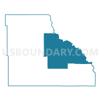
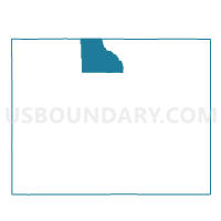
SHELL Voting District, Big Horn County, Wyoming
About
Outline

Summary
| Unique Area Identifier | 698485 |
| Name | SHELL Voting District |
| County | Big Horn County |
| State | Wyoming |
| Area (square miles) | 653.72 |
| Land Area (square miles) | 653.05 |
| Water Area (square miles) | 0.68 |
| % of Land Area | 99.90 |
| % of Water Area | 0.10 |
| Latitude of the Internal Point | 44.55176160 |
| Longtitude of the Internal Point | -107.61127320 |
Maps

Graphs
Select a template below for downloading or customizing gragh for SHELL Voting District, Big Horn County, Wyoming


Neighbors
Neighoring Voting District (by Name) Neighboring Voting District on the Map
- BASIN Voting District, Big Horn County, WY
- BIG HORN WOMENS CLUB Voting District, Sheridan County, WY
- BUFFALO RURAL WEST Voting District, Johnson County, WY
- DAYTON OUTSIDE Voting District, Sheridan County, WY
- GREYBULL Voting District, Big Horn County, WY
- HYATTVILLE Voting District, Big Horn County, WY
- LOVELL Voting District, Big Horn County, WY
- MANDERSON Voting District, Big Horn County, WY
- PINEY-SHELL Voting District, Johnson County, WY
Top 10 Neighboring County Subdivision (by Population) Neighboring County Subdivision on the Map
- Buffalo CCD, Johnson County, WY (7,737)
- Central Big Horn CCD, Big Horn County, WY (3,555)
- Sheridan West CCD, Sheridan County, WY (2,628)
- South Big Horn CCD, Big Horn County, WY (2,542)
Top 10 Neighboring Place (by Population) Neighboring Place on the Map
Top 10 Neighboring Unified School District (by Population) Neighboring Unified School District on the Map
- Johnson County School District 1, WY (8,569)
- Sheridan County School District 1, WY (4,623)
- Big Horn County School District 2, WY (3,430)
- Big Horn County School District 3, WY (3,029)
- Big Horn County School District 4, WY (2,244)
Top 10 Neighboring State Legislative District Lower Chamber (by Population) Neighboring State Legislative District Lower Chamber on the Map
- State House District 40, WY (9,987)
- State House District 51, WY (9,357)
- State House District 26, WY (8,841)
- State House District 28, WY (7,894)
Top 10 Neighboring State Legislative District Upper Chamber (by Population) Neighboring State Legislative District Upper Chamber on the Map
- State Senate District 22, WY (19,515)
- State Senate District 19, WY (18,532)
- State Senate District 21, WY (18,170)
- State Senate District 20, WY (16,427)
Top 10 Neighboring 111th Congressional District (by Population) Neighboring 111th Congressional District on the Map
Top 10 Neighboring Census Tract (by Population) Neighboring Census Tract on the Map
- Census Tract 6, Sheridan County, WY (4,697)
- Census Tract 9627, Big Horn County, WY (3,555)
- Census Tract 9626, Big Horn County, WY (2,542)
- Census Tract 9551, Johnson County, WY (2,475)
Top 10 Neighboring 5-Digit ZIP Code Tabulation Area (by Population) Neighboring 5-Digit ZIP Code Tabulation Area on the Map
- 82834, WY (7,585)
- 82431, WY (3,552)
- 82426, WY (2,644)
- 82836, WY (1,073)
- 82441, WY (250)
- 82428, WY (139)